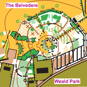
Weald Park
EAL and SWELL (round 1)
Sun 24th Sep 2017
Type of event: Regional
Type of terrain: Parkland, Woodland
League: SWELL, EAL
Results
- Individual results by course with voided legs for courses affected by misplaced control 128 - updated 22.05 (24/09)
- Split times (raw times without voided legs)
- Graphical display of splits (Splitsbrowser)
- Graphical display of splits (Winsplits)
- RouteGadget - add and display routes
Info
Controller's Comments
I would like to thank Philip Cooper for his controlling of the event until the day itself when I took over. We were blessed with good weather and many enjoyed Rachel's challenging courses. Unfortunately control kite 128 was mis-placed on the day and this was not spotted until part way through the event. It was placed on the northern thicket whereas the control site on the map was on a thicket which was 50m further south. My apologies to all that were adversely affected; the legs to and from control 128 have been removed from the results. The tape marking the correct control site, like the tapes for most sites, had been eaten by the herd of several hundred deer that now live in the Park. Unfortunately the deer did cause some difficulties for a few competitors but I hope you all enjoyed your day.
Paul Beckett (HAVOC)
Planner's Comments
We hope you all enjoyed the courses, despite the misplacing of control 128. Weald Park is a lovely area with great views, and we were blessed with wonderful weather. Paul was not only the on the day controller, but also spent many hours in the weeks leading up to the event updating the map - thank you Paul. Our thanks also go to Phil Cooper who was the controller until the day of the event. His advice and tips on the courses were invaluable. Colin, once again, was a superb organiser supported by many HAVOC members: (Doug McTurk, Barbara Beckett, Graham Batty, Janet Biggs, Tony Biggs, Dale Bennett, Chris Shaw, Mike Muggeridge, Anne Power (LOK)).
Rachel McTurk (HAVOC)
A level C Ranking event incorporating EAL (East Anglian League) and the first 2017/18 SWELL (South & West Essex Local League) fixture.
By virtue of competing at a SWELL event you qualify for entry into that league.
IMPORTANT: Older type SI control boxes will be used for timing at this event. These boxes DO NOT support newer dibbers (SI cards). ONLY the classic SI-card 5, numbered 1 to 499,999 is definitely supported. SI-card 6, numbered 500,000 to 999,999 should work as well but we have not been able to test them. Therefore, if you do not have an SI card (dibber) with a number less than 500,000, you will need to hire one, for free, at the event.
Location
/0.2689173999999639,51.6213768,12/500x400?access_token=pk.eyJ1IjoicGF1bGZyb3N0IiwiYSI6ImNrenZxN2s0YjZvMGIybm8xaGNxb3ltYXYifQ.dl7YKehDTCGbfoxMRiVe7g)
Nearest town: Brentwood
- Grid Ref: TQ570940
- Postcode: CM14 5QJ
- Latitude: 51.62138
- Longitude: 0.26892
- Google Map (aerial)
- Bing Map (OS)
- OpenStreetMap
Directions / Parking
One mile from M25 J28/A12 junction at the ‘Cricket Field’ car park, off Weald Road, opposite the junction with Weald Park Way. Grid Ref. TQ 573940, postcode CM14 5QJ. Essex County Council car parking tiered charge of £2 for 1 hour, £3 for 2 hours, £4 for 3 hours, £5 for over 3 hours, "pay & display" (no change given, 5p coins and above accepted including new £1 coins). The car park charges go towards maintaining and improving the park and visitor facilities.
Facilities
Toilets adjacent to car park. Visitor Centre with light refreshments 500m.
Start and Finish within 150-250m of the car park.
Other attractions: Lake with wildfowl, a deer enclosure and a picnic area. Stick Man play trail for the young and young at heart.
Terrain Description
OCAD map of the former grounds of the Weald estate with recent updates, 1:10,000 scale. Terrain is gently contoured and comprises undulating mature woodland, a deer park, lakes, landscaped open and rough open areas. Map drawn to ISOM 2000 standard with the following special symbols:- elongated H = seat; black X = hide; black O = vent or play equipment; brown X = rootstock; blue X = tap or water trough; green O = distinctive tree.
Registration & Start Times
Registration 10:00 am to 12 noon.
Starts 10:30 am to 12:30 pm.
Courses close 2.30 pm.
Course Information
A range of colour coded courses: White, Yellow, Orange, Light Green, Short Green, Green, Blue and Brown. Courses will be suitable for beginners, improvers and experienced orienteers. Help and coaching will be available for beginners/improvers (please ask at Registration). Maps will be overprinted on waterproof paper or bagged.
Due to forestry work some paths will be marked with purple crosses ("forbidden route") and some copses with purple OOB. Note rabbits are a problem in the area, keep a look out for rabbit holes. Deer and a small herd of redpoll cattle roam freely, do not approach them and make sure gates are closed.
Entry Details
Seniors £7 (£2 surcharge for non-British Orienteering members.)
Juniors £3.
Electronic punching will be used at this event – SI ‘dibber’ hire fee 50p.
Pairs and groups pay one senior fee only but should take only one map.
Contacts / Officials
Planner: Rachel Cooper & Doug McTurk
Organiser: Colin Jackson (HAVOC) email
Controller: Phil Cooper (WIM) assisted by Paul Beckett (HAVOC)
Dogs allowed?
Dogs must be kept on a lead.
Safety and Risk
A comprehensive risk assessment will have been carried out by the organiser, but participants take part at their own risk and are responsible for their own safety during the event.
Privacy: when entering our events your name may appear in the results section of this website or in newspaper reports.
Read our privacy policy to see how we look after your personal data.